
The quadcopter is carrying a companion computer (with external battery) that’s connected to an Iridium modem. The stock 3DR hand controller is also attached to the quadcopter. Nothing is hardwired to the quadcopter or hand controller and no modifications, hardware or software, were made to the quadcopter or hand controller.
The companion computer acts as an interface between the modem and the Unmanned Aerial System (UAS). In this example with a 3DR Solo, the companion computer communicates with the hand controller and the hand controller communicates with the quadcopter. However, the companion computer operates in a vehicle-agnostic manner and can interface with any MAVLink vehicle.
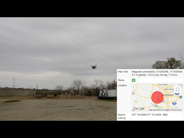
The companion computer is programmed to listen for a command to launch, then execute a predetermined flight plan. In this case, the flight plan just commands a waypoint (37.5261575° Latitude, -77.43310322° Longitude, 4 meters altitude), then commands a return to the launch position. Shortly before the recording started, the launch command was sent via smartphone from the modem vendor’s web interface. I was standing right in front of the quadcopter when I sent the launch command, but the launch command could have been sent from anywhere on Earth and the flight would have been executed the exact same way.
During the flight, the companion computer sent two status updates, which could be read on the modem vendor’s web interface. The first update showed that the companion computer successfully issued a waypoint command and also included current quadcopter telemetry. The telemetry showed current quadcopter position, current altitude (in a global reference frame), current altitude (relative to takeoff position), current heading, and current groundspeed. The second update showed that the quadcopter was returning to the launch position and also showed current position and altitude (in a global reference frame). When the return started, the quadcopter’s Latitude/Longitude was within 0.5 meters from the commanded waypoint’s Latitude/Longitude. The “Approx Lat/Lng” region shown in each map is the Iridium satellites’ estimate of the origin of that transmission. Not completely accurate, but a decent estimate from doppler shift calculations.
 UrduHindi")


 Communication)